Orosei’s hinterland
to the map with the marked sights
Giants’ tomb S’Ena e Tomes

This tomb is one of the largest of its kind in Sardinia.
Like the tombs in the Arzachena area, this complex dates from the Nuragher period.
The enormous stone stele at the entrance is about 3.70 m high. Behind it there’s the burial chamber of about 10 metres long, covered with heavy stone slabs. The tomb is completely isolated in the middle of the valley.
The tomb is located completely solitarily in the midst of low macchia on a hill.
How to get there: Coming from Orosei, turn off the SS 129 at La Traversa onto the SP 38 and drive towards Lula, Bitti.
After about 4 km there is a sign on the right indicating the site. Leave your car here and follow a trail for about 500 m.
The Nuragic village Serra Orrios
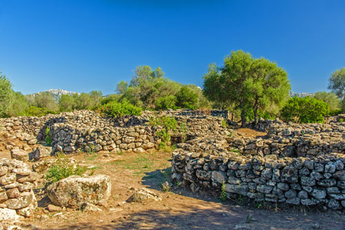
Serra Orrios is by far the largest Nuragher settlement that has been excavated in Sardinia.
However, no Nuraghe can be found here. The settlement dates back to the period of the Nuragic culture, between 1200 and 900 BC. Like other settlements, which arose in the same period, the huts were also built in the vicinity of the ritual place.
This cult place with its Megaron-temple is still surrounded by a high wall. The term megaron refers to a rectangular temple shape that had developed in the ancient Greece. It is therefore quite possible that foreign influences from other cultures had already been present at that time. Only 20 temples of this type are known to exist in Sardinia today.
By now, 100 structures have been excavated in Serra Orrios, including 49 round huts with outbuildings and 2 Megaron-temples.
 The walls of the typical round huts were about one metre thick. In the middle was an open fireplace, which is still recognisable in many huts. A conical roof was built over it made of wood and twigs.
Some walls have niches, which probably were used to store things.
The settlement was dug out in the years 1936-38 and inspected again in 1986.
The objects found are exhibited in the Archaeological Museum in Dorgali. You can buy a combined ticket for Serra Orrios and the museum here.
How to get there: Serra Orrios is located next to the SP 38, about 8 km from Dorgali (see map). If you come from Dorgali, first drive towards Oliena and, after crossing the reservoir, turn right towards the SS 129. The site is quite well signposted.
Sorgente Su Gologone
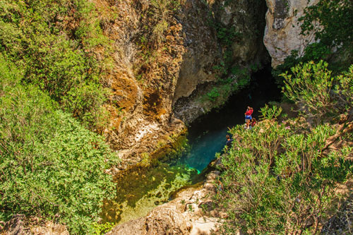 This spring is the greatest and most beautiful one in Sardinia.
However, the fame of this small natural wonder has now led to the fact that, at least in the high season, it is crowded and an entrance fee is charged here as well. However, the beautiful site is well cared of.
You can rest in a small shady park and at the car park fill up your bottles with water from the spring. Motorhome drivers are also allowed to fill up with water there.
The whole area is beautifully green and forms a lovely oasis of eucalyptus trees, oleanders and the river Cedrino flowing nearby. A bar offers snacks and refreshments.
By following the creek from the car park, you’ll soon reach a crevice. Water streams out there up to 300 l per second, depending on the season. The crystal clear and cold water in the crevices creates a little pond, which seems to be endlessly deep. The small church Nostra Signora della Pietà watches over it.
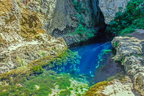 The water of the spring originates from the widely branched cave system of the Supramonte massif. In 1999, speleologists wanted to determine the underground water courses more precisely. They added the green dye uranin to the water in the S’Edera cave near Urzulei. It took about a month for the water to traverse the Supramonte caves and come out again here at the source.
This clear, 12° C cold water has been attracting the world’s best cavers for a long time and many attempts were made to reach the cave’s bottom.
Unfortunately one diver died. Over the years, divers came down to a depth of 135 m – without ever having reached the bottom.
Visitors are strictly forbidden to swim or even dive here.
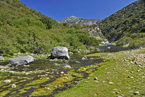 Underneath the church, you can cross the outflow of the spring and take a nice walk along the banks of the Fiume Cedrino.
Since most tourists stay near the spring and at the bar in the park, it is quite calm here.
The water is clear, but the bedrock is partially muddy.
Depending on the season, the water level fluctuates by several metres, which can be easily seen from the high-water marks on the rocks. If the water level allows it, paddling tours are offered here by a cooperative.
Unlike the spring, bathing here is allowed.
Sa Sedda ’e Sos Carros
 From Su Gologone, you can drive a bit further and visit the Lanaittu Valley.
Here, you will find a very interesting archaeological site and three caves to explore.
The valley is also the starting point of one of the hiking trails leading up to Monte Tiscali.
Sturdy footwear is recommended for visiting the individual sites!
The Nuragic complex of Sa Sedda ’e Sos Carros was only discovered in 1977 and partially excavated in 1993. The site dates back to the Middle Bronze Age and was constructed around 1300 BC.
So far, several circular huts and a very well-preserved sacred well can be viewed.
The complex housed workshops for bronze processing, and numerous bronze artifacts were discovered there.
The site also features a kind of altar with remnants of bronze swords. These were likely driven into the stone as offerings and secured using molten bronze.
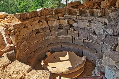 The sacred well is unique in its kind on Sardinia.
The walls are constructed from carefully smoothed limestone and basalt blocks. The basalt had to be transported to this site, as it does not naturally occur in the area.
Running along the wall is a bench, above which are artistically crafted ram heads made of limestone. These ram heads were connected to a higher-lying basin via water conduits. Water would flow from their “mouths” into a large central basin, which was carved from a single monolith.
The upper basin served as a water reservoir. It was made from large basalt blocks, with its base sealed using clay.
The precision of the craftsmanship and the advanced knowledge of hydraulic system construction displayed here are truly remarkable.
Grotta sa Oche and Grotta su Bentu
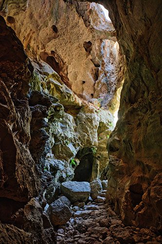 These two caves are freely accessible without a guide.
Both caves are located behind the bar, although during my visit, only the Grotta sa Oche was signposted.
The two caves are connected by a siphon over 100 meters long.
Until the 1960s, this complex karst system was considered the longest cave in Italy, with a network of passages extending over 16 kilometers.
The lakes, the enormous chambers, the height differences that sometimes exceed 100 meters, and the vastness of the karst network make it one of the most unique caves in Sardinia.
Cave explorers often refer to it as the “Grotta Palestra” (Training Cave).
Ongoing explorations and speleological research are conducted here by local, national, and international scientists.
The name “Sa Oche” (The Voice) originates from the powerful roaring noises produced by the water in the cave after heavy rainfall.
At times, the cave overflows, and torrents of water gush out with a deafening roar from its entrance.
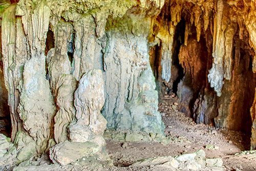 The entrance to Su Bentu is about 60 meters higher than the entrance to Sa Oche.
You can reach Su Bentu via a narrow path that branches off to the left just behind the bar and leads steeply uphill.
A cold stream of air usually flows out of the Su Bentu entrance, giving the cave its name, “Su Bentu” (The Wind).
In the past, this airflow was used to preserve food such as fresh meat.
How to get there:
Shortly before the Su Gologone parking area, a road branches off to the right. Initially paved, it soon becomes an unpaved track that runs approximately 7 kilometers through the valley.
At the end, you will find a parking area near the Rifugio Sa Oche (see map). Here, you will also find a bar and the ticket office for guided tours.
Grotta Corbeddu
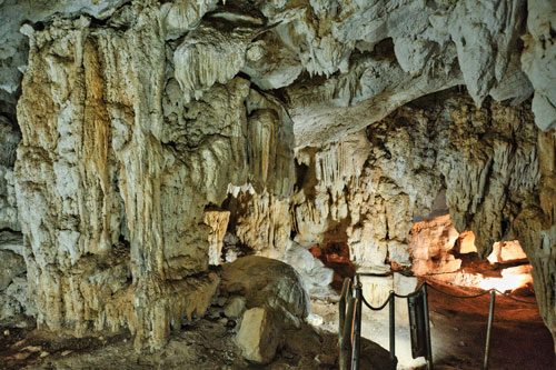 Grotta Corbeddu, like the Nuragic village, can only be visited as part of a guided tour.
This cave, which stretches for approximately 150 meters, is named after the famous bandit Giovanni Corbeddu, who used it as a hideout during his years in hiding.
Since 1982, excavations have been conducted in the cave, revealing that it was inhabited from the Stone Age to the Bronze Age.
In the lower layers, a fragment of a human parietal bone and an upper jaw were discovered, dating back to around 14,000 BC.
Additionally, tools made of obsidian and flint, as well as fragments of ceramics, were found.
These human relics were unearthed alongside numerous bones of extinct endemic animals.
Tiscali
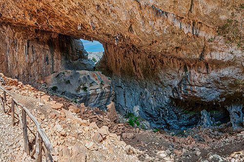
Here, the Nuraghe built a secluded settlement in a collapsed sinkhole, protected from the summer heat and the cold winter winds by the overhanging rock walls. The natural rock walls were integrated into the structures to make optimal use of the available space. The buildings display various floor plan shapes: square, rectangular, round, and oval. Evidence has been found of both residential buildings and stables. It is estimated that up to 200 people may have lived here.
The water supply remains unclear, as the nearest spring is approximately 7 km away.
Tiscali can only be reached on foot — either from the Valle di Lanaittu or from the Valle di Oddeone.
A route description for the hike from Valle di Lanaittu can be found here.
