![]()
Su Golgo Plateau, Sa Pedra Longa, Santa Maria Navarrese
map of Su Golgo and surroundings
The Su Golgo Plateau lies above the municipality of Baunei. It is easily accessible by car or motorcycle.
In Baunei, a steep asphalt road branches off and winds up through several hairpin bends. At the top, the road flattens out and leads through sparse woodland deep into the plateau.
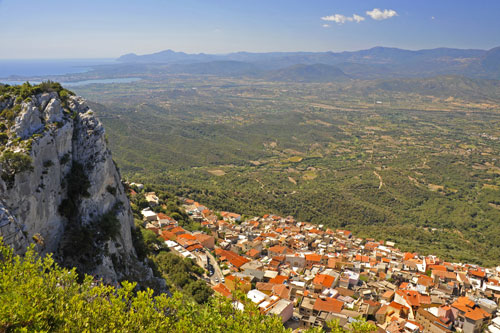
Shortly after the ascent, a dirt track on the right leads to the viewpoint “Sclaradorgiu S. Franciscu”.
From here, you have a breathtaking view of Baunei below and far into the Ogliastra region.
Proceed with caution as countless animals roam freely up here.
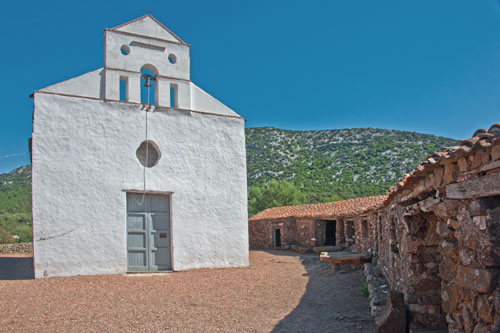
The asphalt road continues for about 7 km across the plateau and turns into a dusty track near the Church of San Pietro di Golgo.
Next to the church, there are several pilgrim cells, and ancient olive trees stand in front, providing shade for resting.
The small church is an excellent starting point for short hikes.
There is ample parking available.
You will often find goats, donkeys, and pigs here, accustomed to tourists and happy to be fed by them.
Your children will surely enjoy this.
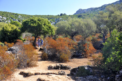
The plateau is crisscrossed with many paths, mostly leading through sparse holm oak forests and maquis.
For longer hikes, you can walk from here to the sea.
The track that continues north from the Church of San Pietro is initially passable by car, but in the Codula di Sisine, you can only continue on foot or by mountain bike until you reach the bathing bay of Cala Sisine.
It is about 15 km from the church to the bay.
The path to Cala Goloritze is much shorter. From the starting point at the Su Porteddu campsite, it’s about 3.5 km with an elevation difference of nearly 500 m.
The return trip is also quite strenuous.

A few minutes from the Church of San Pietro is the deepest karst hole in Europe, the “Voragine del Golgo” or “Su Sterru.” (see map)
It is about 270 m deep with an oval diameter of 25 m at the top and 40 m at the bottom.
The upper section, 26 m thick, consists of basalt, with the rock below being limestone.
The small viewing platform is secured with a railing.
In the photo, you can see two speleologists abseiling into the depths during our visit.
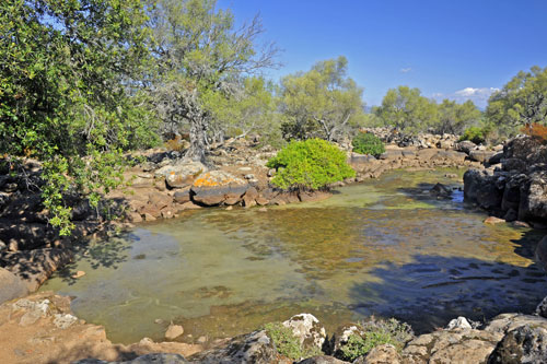
If you walk about 200 m south from the karst hole, you will reach several small water pools “As Piscinas.” (see map)
Here, rainwater collects, creating a small oasis amid rocks and gnarled trees on the otherwise very dry plateau.
The pools never dry out completely, even in the hot season, and serve as water sources for the animals living here.
Sa Pedra Longa
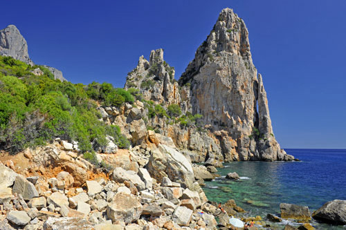
About 1 km south of Baunei, a road branches off to the left towards the sea.
Several hairpin bends lead to a restaurant and several parking areas. The drive itself offers great views of the picturesque rocky coast and the massive rock needle “Sa Pedra Longa.”
From the lowest parking lot, several paths lead down to the sea. Swimming opportunities are quite limited as the rocks extend into the water.
The nearest larger sandy beach is about 5 km away in the seaside resort of Santa Maria Navarrese, which you can also reach on foot from here.
The hiking trail starts above the restaurant in one of the hairpin bends and runs about 100 m above the sea along the impressive coast.
The restaurant is only open during the bathing season and offers a fantastic view from its terrace.
Santa Maria Navarrese

The small seaside resort has a beautiful beach located directly below the coastal road.
The beach consists of fine pebbles, and south of the village, a 6 km long sandy beach stretches towards Arbatax.
Even in the peak season, it remains relatively quiet here.
In the central square, there are several ancient olive trees and a small church that gave the village its name. A Spanish princess built this church in the 11th century after being shipwrecked here.
On the protruding cape at the northern end of the bay, there is still a Spanish Saracen tower, and behind it lies a small marina.
Boat trips to the Gulf of Orosei are also offered there.