![]()
Is Pirois, Funtana Coberta, Pranu Muteddu
map of Is Pirois, Funtana Coberta, Pranu Muteddu
Is Pirois Well Temple
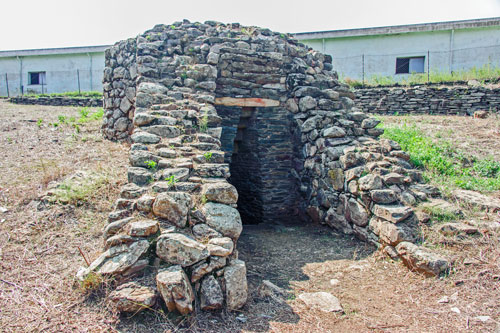
The sanctuary dates back to the Bronze Age, around 1600 BC.
In terms of architecture, it differs from other well temples because it is the only one that forms the lower part of a Nuraghe.
As with the sites of Santa Cristina or Su Tempiesu, steps lead down to the spring here, and the ceiling of the entrance is also designed like an inverted staircase.
Even in the dry summer, the spring still carries water.
How to Get There: Take the old SS125 until you reach the bridge over the Rio S. Giorgio. Right at the northern end of the bridge, an unpaved track branches off. Here, there is also a signpost “Tempio a Pozzo” (Well Temple). Follow the track for 1 km until you reach a ford, then turn right after crossing it. After 800 m, leave your vehicle and continue on foot. (see map)
Funtana Coberta
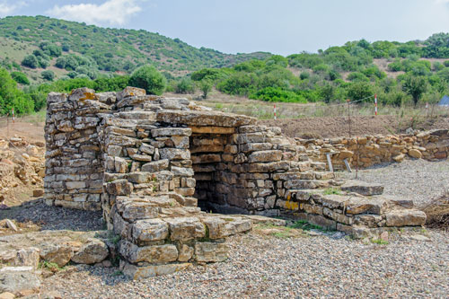
The temple was first excavated in 1918 and simply referred to as the “covered well – funtana coberta.”
It was built by the Nuragic people around 1000 BC.
Remnants of the forecourt are still preserved, and a staircase leads down to the actual well shaft.
At the bottom is a paved, circular room, in the center of which the well was dug 5 meters deep into the rock. Above it, the structure’s dome-shaped roof arches.
How to Get There: The well temple is easy to find. From Balao, drive approximately 4 km on the SP6 towards Escalaplano. Just before the turnoff to Goni, there is an unpaved access road on the left leading to a small parking lot. From here, it’s only about 100 meters on foot. (see map)
Through the Mountains of Sarrabus
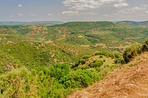
A drive through the interior of Sarrabus is also incredibly scenic and is recommended for those looking to escape the summer bustle at the seaside.
Plan plenty of time for this journey as the roads are extremely winding. There is very little traffic, making the area particularly appealing for visitors with motorcycles or bicycles.
However, it’s worth noting that there are also extreme inclines and descents to navigate.
Beautiful views of the gentle hillsides open up repeatedly.
Apart from a few attractions, the area is scarcely developed for tourism and, in many parts, appears nearly uninhabited.
Pranu Muteddu

The archaeological park of Pranu Muteddu is one of the most significant prehistoric sites in Sardinia.
The site was only discovered in 1975. In the 1980s, numerous relics were excavated on approximately 200,000 square meters.
Here, one can find one of the largest collections of menhirs in Sardinia, totaling around 60, which were arranged in rows, pairs, or groups.
The largest alignment of menhirs was precisely erected in an east-west direction. This alignment allows them to form a line with the rising and setting sun during the equinoxes.
This confirms that the early cultures in Sardinia were engaged in astronomical observations, which evidently were part of their religious rituals.
In addition to the menhirs, some burial sites from the Neolithic period have also been preserved.
Through artifacts, researchers were able to date the graves and menhirs to approximately 3200-2800 BC.
While the menhirs are comparable to those at the Biru ‘e Concas site, the graves exhibit more similarity to those at Li Muri.
The graves are surrounded by several wide stone circles, which were originally part of the enclosure of the burial mound.
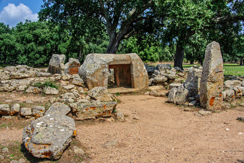
Grave II (photo) has two burial chambers carved out of sandstone blocks. The entrance consists of a single rock block with a tunnel and two lateral niches.
The resemblance to the rock-cut tombs (domus de janas) is apparent, which are a precursor to the later, more elaborate burial mounds.

It’s likely that religious rituals centered around ancestor worship were practiced at Pranu Muteddu.
This assumption is based on the accumulation of numerous graves and the many menhirs erected here. The site is therefore also referred to as the “Sardinian Stonehenge.”
The size and architecture of the graves vary considerably.
While the entrance to Grave II consists of a hollowed-out rock block, stone rows were incorporated on the sides of the entrances in the other graves.
In some cases, the entrances are flanked by so-called guardian stones, like the three menhirs in the photo, which earned the grave the name “La Triade.”

Pranu Muteddu was established during the late phase of the so-called Ozieri culture and continued to be used thereafter.
In addition to the large burial sites, numerous simple rock-cut tombs (domus de janas) are also found, typical of the Ozieri culture period.
How to Get There: The entrance to the parking lot is located at km 16.2 on SP23 south of Goni. (see map).
Pranu Muteddu consists of two parts on either side of the road. From the parking lot, visitors can access the ticket office in a small visitor center through a tunnel. Here, you can obtain an overview map of the site’s attractions.
The park is located in an extensive, open cork oak forest, providing ample opportunities to rest in the shade.