Macomer and surroundings
map of Macomer and its surroundings with the marked points of interest.
Macomer
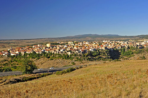 The town has about 10,000 inhabitants and forms the economic center of the region.
Numerous archaeological sites in the surrounding area show that the region was inhabited since the early history of Sardinia.
Under Punic rule, the settlement of Macopsissa was established, which later gained importance under the Romans due to a major north-south traffic route passing through here.
Even today, Macomer remains an important transportation hub. Here, the Trenitalia line from Golfo Aranci to Cagliari intersects with the narrow-gauge lines to Bosa and Nuoro.
The SS 131 (Carlo Felice) also runs through here, which, together with the rail lines, fostered the town’s development.
The most important economic sector is agriculture, especially milk and cheese production.
Nuraghe Santa Barbara
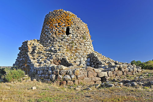
The Nuraghe stands on a hill north of Macomer.
It consists of basalt blocks and is still about 15 meters high today.
The central tower was built around 1000 BC. Of the original three floors, only two remain. Around 400 BC, a rectangular fortification with thick walls and an inner courtyard was added to strengthen the complex.
Originally, the bastion was surrounded by another wall, which is now hardly visible.
From the Nuraghe, you have a beautiful view of Macomer and the Abbasanta plateau.
How to get there: Santa Barbara can be easily reached from the SS 131 – but only if you are driving from Cagliari towards Sassari. There is no turn-off in the opposite direction.
At km 145, a driveway leads to a small parking lot, from which you can walk to the Nuraghe in about 10 minutes. (see map)
Nuraghe Ruju and Filigosa Necropolis
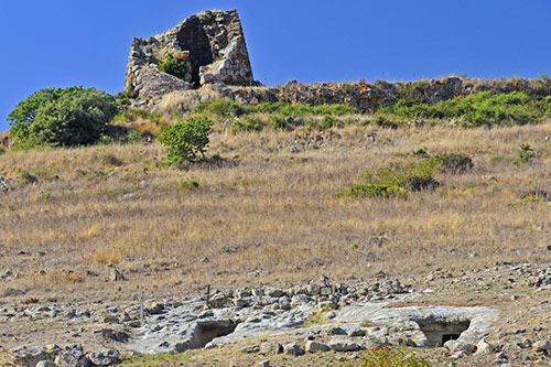 The Nuraghe Ruju (also Ruggiu) is located on a hill at the edge of Macomer, opposite the hospital. (see map)
The structure is half-collapsed, allowing a view inside. The typical construction of the corbelled vault is clearly visible.
Below the Nuraghe, four corridor tombs, known as Domus de Janas (fairy houses), are carved into the rock. Each is accessed via a 10-meter-long corridor, the dromos, at the end of which the actual burial chamber opens. Adjacent are additional side chambers.
Excavations in the 1960s and 1980s unearthed bones and ceramics, dating the use of the tombs to the mid-3rd millennium to early 2nd millennium BC.
Tamuli Archaeological Complex
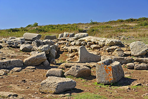
The Tamuli site is located on a plateau about 4 km southwest of Macomer. The complex includes three Giants’ tombs, a Nuraghe with the remains of the associated village, and six menhirs.
Tamuli was established during the Middle Bronze Age around 1500-1200 BC.
The three Giants’ tombs are largely destroyed but could still be classified architecturally as of the later type of these tomb structures.
How to get there: Tamuli is easily accessible from both Macomer and Santu Lussurgiu. In Macomer, a well-marked narrow asphalt road branches off from Via Emilio Lussu.
If you are coming from Santu Lussurgiu, drive through San Leonardo, then turn left towards Sant’ Antonio/Tamuli after another 8 km. Always keep right at the next junctions. (see map)
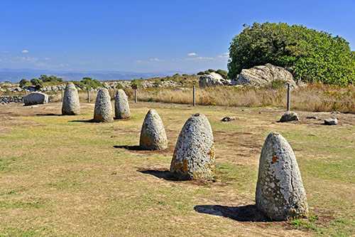 Tamuli is especially known for the six baityloi, also known as betili in Italian. In Sardinian, they are called sas perdas marmuradas.
These specially shaped menhirs are about 1.50 meters high and stand directly next to the Giants’ tombs, emphasizing their significance for cult purposes.
They are made of basalt blocks that have been finely worked and smoothed.
Apparently, the baityloi served a Nuragic stone cult. The veneration of (worked) stones was widespread throughout the Mediterranean.
Three of the cone-shaped menhirs are completely smooth, while the other three each have two breast-like bulges. Presumably, they represent female deities, while the three stones without “breasts” stand for male gods.
 At the edge of the Tamuli complex, the remains of a Nuraghe stand on a basalt rock. The large central tower and two smaller side towers are still recognizable. The structure is not accessible due to the risk of collapse.
Below the Nuraghe, the foundation walls of the Nuragic settlement have been uncovered. So far, 10 huts have been excavated, some of which were used by shepherds as shelters for their animals until modern times.
Nuraghe Succuronis
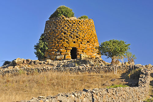 The well-preserved Nuraghe stands on a hill near the SS 129, about 2 km west of Macomer. (see map)
The complex consists of a single tower, about 14 meters in diameter.
It was built with large trachyte blocks that become smaller towards the top. Some light openings are visible in the outer wall, spiraling around the tower.
Inside, a staircase leads to the upper floor.
Nuraghe Santa Sabina/Santa Sarbana
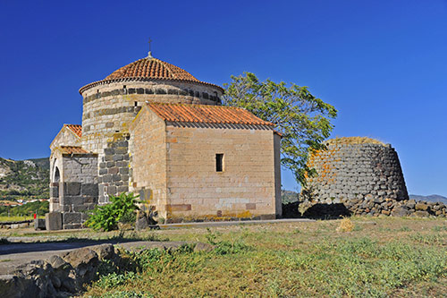 One of the most famous Nuraghes and simultaneously one of Sardinia’s most popular photo motifs is the Nuraghe Santa Sabina (Santa Sarbana).
Right next to it stands a small church from the 11th century, bearing the same name.
There are about 2000 years between the two structures, bringing together the relics of the Nuragic and Byzantine eras in close proximity.
The church was likely built over an older pagan cult site (probably a Giants’ tomb), using the existing material. Basalt blocks from the nearby Nuraghe were used for the floor of the church.
Inside the Nuraghe, a stone staircase leads to the upper platform. From there, you have a wonderful view of the surrounding plateau.
In spring, the church and Nuraghe are surrounded by a magnificent carpet of flowers.
Cherchizzo Sacred Well
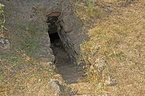 If you are interested in Nuragic culture, you can also visit the sacred well, located 400 meters from the Nuraghe across the road. (see map)
The sanctuary probably belonged to the Nuragic settlement around the Nuraghe Santa Sabina.
The well was discovered in 1881 but was only partially excavated in 1982.
A narrow 5-meter-long staircase leads down to a small chamber covered with a pointed arch.
The structure is dated to the 12th-10th century BC.
East of the Nuraghe are the remains of two Giants’ tombs. There are information boards, but the tombs themselves are not accessible.
Nuraghe Madrone (Nuraghe Orolio)
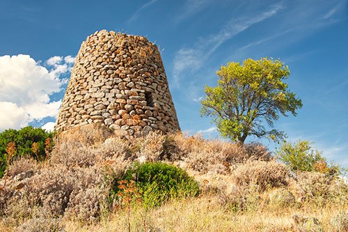
The Nuraghe stands on a hill east of Silanus.
It was built with granite blocks and is still 13 meters high today.
The structure consists of a well-preserved main tower and three largely destroyed side towers.
In the surrounding area, the remains of a village were also found.
Among the Nuraghes on Sardinia, it holds a special position because the upper floor is also completely preserved.
The entrance is at ground level, though it is hidden behind bushes in the photo. Directly above is the window of the second floor.
Behind the entrance is a niche to the right, and a staircase to the left leading up. This staircase is easily accessible and winds in a 360° turn around the inner chamber.
The main rooms of the two floors consist of so-called tholos vaults, which contain several niches.
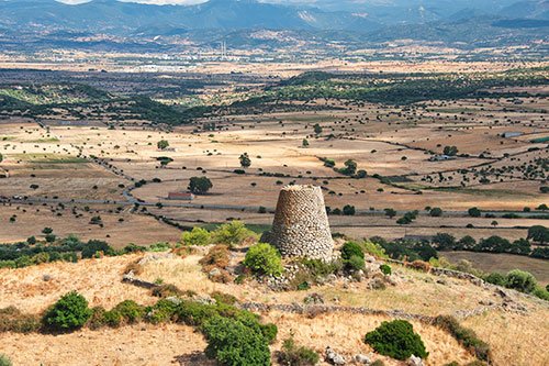
From the second floor, another staircase leads to the upper platform, from which you have a beautiful view of the plain and towards Ottana.
The complex can be freely visited. A flashlight is required for exploring the interior rooms and stairs.
How to get there: The Nuraghe is easily visible from the road. The access is on the road leading east from Silanus towards the SS129 (see map). The road is very winding and unclear, and there are no proper parking spaces. It is best to park in Silanus and walk to the site.
