Osini and Ulassai
map with the marked sights
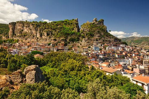
The two mountain villages Osini and Ulassai (photo) are situated in a truly stunning landscape and offer several attractions in their surroundings.
A distinctive feature of the landscape is the local table mountains, called “tacchi” in Sardinia.
They give the area a characteristic appearance that resembles the bizarre rock formations of the Wild West more than a Mediterranean island. The tops of the tacchi are flat and often covered with lush vegetation.
During heavy rainfall, impressive waterfalls form. Some of the rainwater seeps underground, creating enormous caves in the limestone.
Gola della Scala di San Giorgio
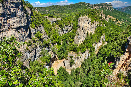 If you are arriving from Gairo, you will first pass through Osini.
There is a sparsely signposted ascent to the Gola della Scala di San Giorgio.
The road is fully paved but very steep and quite narrow in places.
After about 3 kilometers, at the beginning of a hairpin bend, you will find a small ticket booth. (see map)
Here you can park and hike up the gorge to the viewpoint.
The steepest sections have steps, and the ascent takes about 10 minutes.
In the lower third, there is a short detour to a crevice in the rock wall, where a cold downdraft of refreshing air greets you.
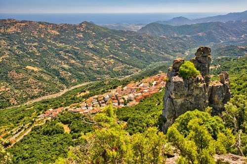
At the top of the viewpoint, you have a fantastic view of the rugged rock landscape, the valley towards Osini, Osini Vecchio, Gairo, and even the sea.
The name Scala di San Giorgio, also called Gola or Arco di San Giorgio, comes from a legend about Saint George (Italian: San Giorgio).
In the 11th century, San Giorgio was consecrated as a bishop at the age of only 22 and was assigned to the diocese of Barbagia, a region that was very difficult to travel through at that time.
His office required him to visit all the parishes in his diocese, and the young bishop was on foot from Seui to Osini when insurmountable vertical rock walls blocked his way.
According to the legend, the rock opened after a prayer, forming the present passage in the massif of Taccu di Osini.
Tip: If you want to visit the Grotta su Marmuri next, you can take a shortcut directly to the cave. Just follow the road from the ticket booth for another 300 meters uphill and turn left at the next junction. (see map)
Nuraghe Serbissi
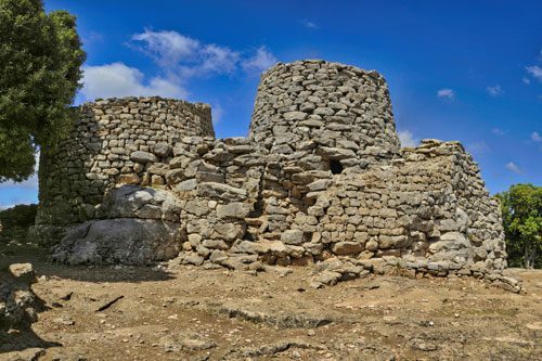
The Nuraghe can only be reached on foot, by mountain bike, or with an off-road vehicle.
Continue uphill from the Gola della Scala di San Giorgio and keep right at both junctions.
After 2 km, at the end of the paved road, there is a small parking lot. (see map)
If you are traveling with a regular car, it is best to leave it here.
From the parking lot, it is another 3 km to the Nuraghe. The path is well signposted and easy to walk. I have marked the track in green on the map.
The trail leads through a light forest across the plateau with gentle ups and downs.
Bring enough water and sun protection, as there is little shade here.
An alternative is a hike from Gairo Taquisara. This route is shorter but significantly steeper. You can also combine the tour with a trip on the Trenino Verde and start the hike directly at Gairo station. I have marked this variant in red on the map.
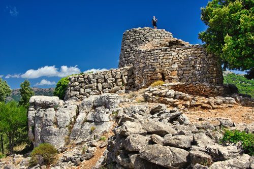
The Nuraghe stands on the northwestern edge of the Taccu di Osini and is also a great viewpoint.
From here, you can see the neighboring table mountains, the Rio Taquisara valley, and the distinctive rock monument Perda e’ Liana.
The structure consists of a main tower and three side towers connected by a wall. The main tower is still about 6 meters high today and can be climbed via a staircase.
In the immediate vicinity are the remains of 8 round huts.
The complex was inhabited from the 17th to 10th centuries BC.
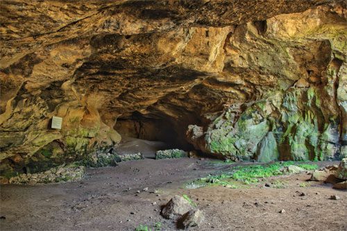 Directly below the Nuraghe is a natural karst cave that can be visited.
The cave is 200 meters long and has two entrances, so you can pass through the mountain under the Nuraghe.
It is very dark in the middle section, so it is best to bring a flashlight.
Small wall remains indicate use by the Nuraghe people, who probably stored supplies here.
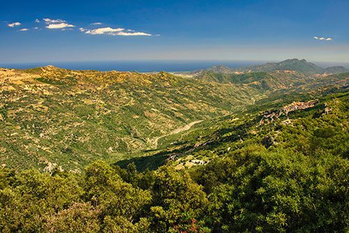
If you hike back towards Osini, you will come across a signposted detour to the viewpoint Su Scrau.
It is only 500 meters to the summit, and from there, you have a great panoramic view.
At the top, there is a small Forestale station, which is usually manned.
Tip: If you want to visit the Grotta su Marmuri next, you can take a narrow, paved connecting road over the plateau, which will take you directly to the cave in just 2 km.
This will save you the huge detour down the serpentine road to Osini.
For better orientation, I have marked this shortcut as a blue route on the map.
Grotta Su Marmuri
In Ulassai, a signposted road branches off to the cave. The road climbs steeply through several curves, offering repeated views of the bizarre mountain landscape.
At the top, there is a parking lot, a restaurant, and a few picnic tables. (see map)
In the peak season, it is better to book in advance to avoid unnecessary waiting times. Tel.: +39 0782 79859
Especially on weekends, the parking lot below the cave is completely full.
The times for the cave tours are posted on a board, but in the quiet off-season, you might wait here in vain. In this case, just ask briefly at the kiosk or the restaurant.
In our case, the tour was held for only two people.
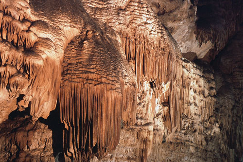
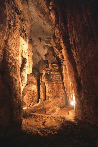 The path inside the cave leads through long halls up to 40 meters high.
The air temperature inside is about 10°C.
Besides warm clothing, you should also wear sturdy shoes, as the ground is somewhat slippery in places.
The Grotta Su Marmuri is one of the largest caves in Sardinia. However, only about 1 km is accessible to visitors.
The guide points out interestingly shaped rock formations, such as the head of a woman (approximately in the middle of the photo) and the “gummy bear” standing in front of it.
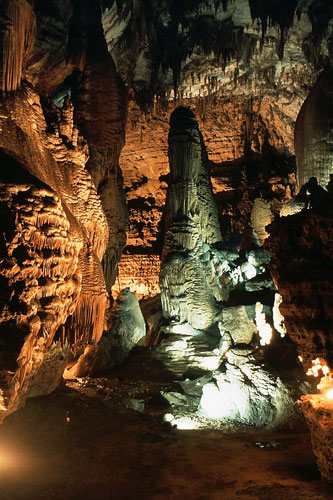
The cave is impressively illuminated.
The water flowing through the halls repeatedly collects into small lakes, reflecting the walls. The dripstones are also differently colored due to the infiltration of various minerals.
Photography with flash is prohibited and is also not effective due to the cave’s dimensions.
We were fortunate to have the tour with just the two of us.
The very friendly guide allowed me to set up my tripod and patiently waited each time. Exposure times of up to 30 seconds were necessary.
Tip: If you want to continue to the Gola della Scala di San Giorgio or Nuraghe Serbissi from here, you can take a shortcut across the plateau. (see the blue route marked on the map)
